Paracel Islands
|
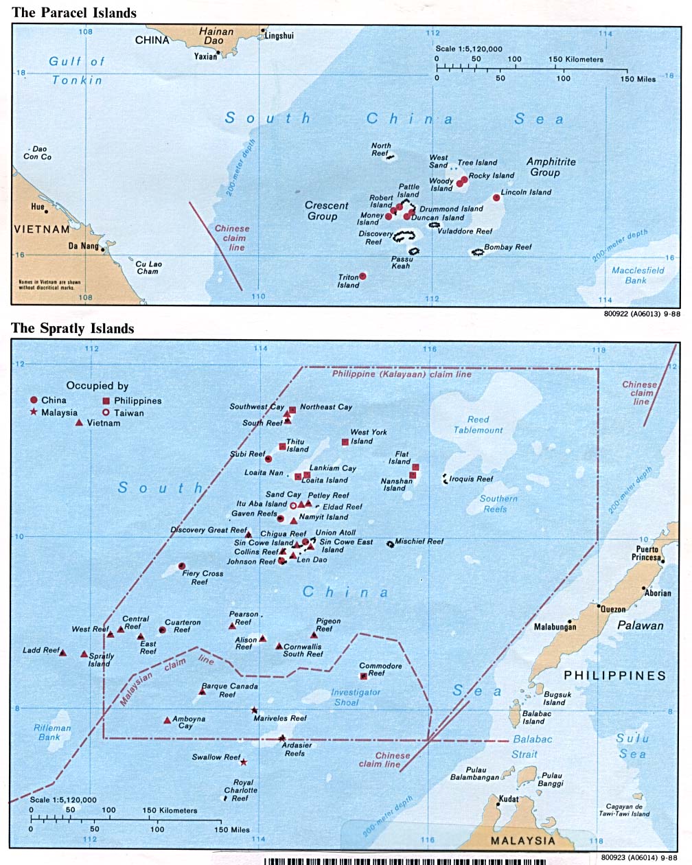
Map
of the Paracel Islands
|
Population: 1,440
(2014 est.)
note: Chinese activity has increased
in
recent years, particularly on Woody Island,
where the population exceeds 1,000; other
islands have scattered Chinese garrisons.
|
....
Chinese cultural
relics in the Paracel islands dating from the
Tang and Song dynasty eras indicate there is some
evidence of
Chinese habitation on the islands in these periods.
....
Ancient Vietnamese maps
record Bai Cát Vàng (Golden Sandbanks, as
claimed today by Vietnam referring to both
Paracel and Spratly
Islands).
1537
Portuguese sailor de Pinto names the islands as
the
Ilhas do Pracel.
1816
Vietnamese flag
planted in a formal ceremony on the Paracels
(Hoang Sa) during the Nguyen dynasty.
1885
China restates its claim to the islands.
17 Oct
1887
Claimed by France as part of French
Indochinese Union (see Vietnam)
(Archipels des Paracels).
3 Oct
1888
Annam Royal Decree No. 1 issued turning Hanoi,
Hai Phong, and
Da Nang (including the Paracels) into concessions of
France,
with the same colonial governance as Cochinchina.
May 1909
Chinese Addmiral Li Jun of the Qing dynasty briefly
visits some
islands there taking symbolic actions (like planing
the flag).
30 Jan
1921
Canton authorities (i.e. the Guomindang government
under Sun
Yat-Sen) local government of Guangdong Province sign
Document
No. 831, issuing a decree to annex the Paracels
(Hsi-sha) under
the management of the Hainan authorities (disputed by
the
governor-general of French Indochina on 8 Mar 1921 who
declared
the Paracels and the Spratlys to be French
territories).
29 Apr
1932
French protest Chinese sovereignty claims over the
islands.
15 Jun
1932
Governor-General of French Indochina signed Decree No.
156-SC,
establishing an administrative unit called Delegation
of the
Paracels (Délégation des Paracels) and annexed
these islands to
Thua Thien Province. This administrative unit was
located far
from the provincial capital and was headed by a French
minister
or officer headquartered on Paracel Island and managed
by the
military force on behalf of the Minister.
25 Jul
1933
French sovereignty definitively
declared on behalf of French
Indochina (see Vietnam),
as part of Ba Ria province (not
recognized by Republic of China).
1938
French colonial government
re-erected the stele of Vietnam's
sovereignty in the Paracels dating back to 1816 in the
Nguye
dynasty and added the words: République Francaise
- Royaume
d'Annam - Archipels des Paracels 1816 - Ile de
Pattle 1938
("French Republic - Kingdom of Annam - Paracel Islands
1816 -
Hoang Sa Island 1938").
4 Jul 1938
The Government of French Indochina
sends a force to officially
claim the Paracel Islands as part of Annam
Protectorate.
Mar 1939
Japan invades the Paracel Islands
and announced (31 Mar 1939) the
merger of both Paracel Islands and Spratly Islands
(occupation
disputed by France [and China]).
Mar 1939 - Sep
1945
Japanese occupation.
30 Mar
1939
Japan declares Paracel Islands are part of Taiwan
province.
23 Apr
1939
Japan declares sovereignty over the Paracel
Islands.
5 May
1939
Governor-General of French Indochina signed Decree
3282 to split
the Paracel delegation into
two units. At that time, the Paracels
consisted of two administrative units called Délégation
administrative des Paracels (Administrative
Delegation of the
Paracels) under Thua Thien
Province, each headed by a Delegation
of the Paracels (Délégation
des Paracels): Nguyet Thiem
(Crossant) and its neighbors; and An Vinh (Amphytrite)
and other
areas in the vicinity.
30 Mar
1941
Annexation by Japan
(announced 31 Mar 1941), part of the Shinnan
Shoto (New Southern Islands), also known as Shinnan
Guntō, under
the province of Takao, Taiwan.
9 Mar 1945
Japan carried out a coup d'état to
ousts all French troops in the
Paracels and the Spratlys, and the Japanese directly
administered the two archipelagos.
May 1945
A detachment of French soldiers
landed on the two archipelagoes
and remained there for several months.
Sep
1945
Japanese troops completely withdrew from the Paracels.
18 Jan 1947
Claimed by Republic of China
(Xisha Islands), part of Guangdong
province.
7 Jul
1951
Claimed by South
Vietnam.
8 Sep
1951
Japan officially renounces sovereignty by
Treaty of San Francisco,
and confirmed on 28 Apr 1952 by
China-Japan Peace Treaty.
24 Mar 1953
China creates the 'Paracels,
Spratlys, and Zhongsha Islands
Authority' established as a county-level
administrative division
on Woody Island (named 4 Mar 1963 - 22 Oct 1981
Paracels,
Spratlys, and Zhongsha Islands Revolutionary
Committee) within
Guangdong (from 1984 Hainan).
22 Oct
1956
Formally annexed by South Vietnam,
part of Phuoc Tuy province.
15 Jun
1956
North Vietnam declares that the Xisha and Nansha
(Spratly) Islands are historically Chinese
territories.
13 Jul
1961
Placed under Quang Nam province by South Vietnam.
19 Jan
1974
Annexed by the People's Republic of China, part of Guangdong
province (as Xisha Islands)(from 13
Apr 1988, Hainan province);
South Vietnamese forces are expelled.
2 Jul
1976
Claimed by Vietnam (Hoang
Sa).
21 Jun 2012
National Assembly of Vietnam
passed a law demarcating Vietnamese
sea borders to include the Spratly and Paracel
Islands.
24 Jul
2012
China announced the establishment of the
prefecture-level city of
Sansha covering the Paracel and Spratly Islands.
18 Apr
2020
China approved the establishment of a municipal
district of Xisha,
in Sansha City, Hainan province covering Paracel
Islands.
Territorial Disputes: Occupied by China, but
claimed by Vietnam and Taiwan.
Spratly Islands
Map
of the Spratly Islands
-----------------------------------------
Map
of competing claims
----------------------------------------
Map
of occupations
|
Population: China
(about 450 soldiers); Malaysia (70-90); the
Philippines
(about 100); and Vietnam (about
1,500);
Brunei is a claimant but has no
outposts.
(no indigenous inhabitants)
note: there are scattered garrisons
occupied by military personnel of several
claimant states.
|
....
Ancient Vietnamese
maps record Bai Cát Vàng (Golden Sandbanks,
as
claimed today by Vietnam referring to both
Paracel and Spratly
Islands).
1211
Island group is first shown on a Chinese map.
1405
Visited by China (Nansha Qundao [Southern Islands]).
1530
Sighted by Portuguese explorer Alvarez de Diegoz.
1606
Claimed by Spain as part of the Philippines .
1791
Visited by British Capt. Henry Spratly discovers
Mischief Reef.
1710
Chinese Qing (Ch'ing) dynasty claims two northern
islands and
builds
a temple on North East Cay.
1798
British navy builds an iron observation tower on Itu
Aba.
1802
Claimed by Vietnam (Truong Sa [Long
Islands]).
29 Mar 1843
British whaling Capt. Richard
Spratly spotted what is now known as
Spratly Island and Ladd Reef.
1877
Captain James George Meads, master of the ship
"Modeste" reportedly
re-discovered the islands and claimed the archipelago
"on behalf
of the world's downtrodden and persecuted." Captain
Meads named
the island group the "Kingdom of Humanity" and the sea
that
surrounded it, the "Humanity Sea." Meads' ancestors
later claim
to have establish a kingdom on the islands.
1885
China restates its claim to the Southern Islands.
1887
Claimed by France as part of French Indochina (see Vietnam).
1893/97
Britain declares a
protectorate over the islands.
10 Dec
1898
Specifically excluded from Philippine territory by
Treaty of Paris.
13 Apr
1930
France occupies Spratly Island, île de la Tempête.
1932
China protests French sovereignty over the islands.
21 Dec
1933
Annexed by France to French Cochinchina (see Vietnam),
merging
Spratly Island, Amboyna Cay, Itu Aba Island, Northeast
Cay,
Southwest Cay, Loaita Island, Thitu Island and other
dependent
islands with Ba Ria province (not recognized
by Republic of
China).
1935
Republic of China announced a sovereignty claim on the
Spratly
Islands.
15 Jun
1938
Established as the administrative unit of Truong Sa
within Thua
Thien province by the Governor-general of French
Indo-China.
30 Mar
1939
Japan declares the Spratly Islands a protectorate
under the
jurisdiction of the province of Takao,
Formosa.
Apr
1939
Japan occupies Spratly Island, named as Nishitori
jima.
5 May
1939
Divided into 2 agencies: Croissant and dependencies
and Amphirite
and dependencies, by Governor-general of French
Indo-China.
12 Dec 1939 - Aug 1945 Occupied by
Japan.
30 Mar
1941
Annexation by Japan (announced 31 Mar
1941), Named Shinnan Shoto
(New Southern Islands), also known as Shinnan Guntō,
as part of
Taiwan province. Japanese build a submarine base on
Itu Aba
(Nagashima).
Jul
1946
Made part of Guangdong province by China. Spratly
Island renamed
Nanwei.
Nov/Dec
1946
Nationalist Republic of China forces establish a
garrison on Itu
Aba.
7 Jul
1951
Claimed by South
Vietnam.
8 Sep
1951
Japan officially renounces sovereignty by
Treaty of San Francisco
and confirmed on 28 Apr 1952 by China-Japan Peace
Treaty.
15 May
1956
Claimed by Philippine citizen Tomás Cloma (b. 1904 -
d. 1996) as
the new state of Kalayaan (Freedom Land).
15 Jun
1956
North Vietnam declares that the Nasha and Xisha
(Paracel)
Islands are historically Chinese territories.
22 Oct
1956
Formally annexed by South Vietnam,
part of Phuoc Tuy province.
8 Jun
1956
Taiwan takes Itu Aba (Taiping) island from
Philippines.
13 Jul
1961
Placed under Quang Nam province by South Vietnam.
1969 -
1971
U.S. radar station on Spratly Island.
10 Jul
1971
Claimed by the Philippines (from Apr 1972 incorporated
into Palawan
province).
29 Apr
1975
'Liberated' from Saigon regime by Provisional Republic
of South
Vietnam.
1 Jul
1976
Claimed by Vietnam (Truong
Sa), part of Khanh Hoa province.
1978
China occupies six atolls, taking them from Vietnam,
part of
Guangdong province (from 13 Apr 1988, Hainan
province).
11 Jun
1978
Philippines officially annexes the islands.
21 Dec
1979
Malaysia occupies Swallow Reef (Terumbu Layang);
Malaysia publishes
a map of its continental shelf that encompasses 12
Spratly
Island features as part of Sabah state.
1983
Malaysia claims Malaysia occupied Swallow Reef (Layang
Layang),
and Amboyna Cay as part of Sabah
state.
1984
Brunei establishes an exclusive fishing zone that
encompasses
Louisa Reef.
25 Feb
1992
Officially declared part of China by "Law on the
Territorial Sea
and the Contiguous Zone."
Feb
1995
China occupies Mischief Reef, Chinese fishing crews
later expelled
by Philippine forces on 20-28 Mar 1995.
4 Nov
2002
Claimants sign the "Declaration on the Conduct of
Parties in
the South China Sea."
21 Jun 2012
National Assembly of Vietnam passed a law
demarcating Vietnamese
sea borders to include the Spratly and Paracel
Islands.
24 Jul
2012
China announced the establishment of the
prefecture-level city of
Hainan named Sansha covering the Paracel and Spratly
Islands .
Jan
2013
Philippines formally initiated arbitration proceedings
against
China's claim on the territories within the "nine-dash
line" that
includes Spratly Islands, which it said is "unlawful"
under the
United Nations Convention on the Law of the Sea
(UNCLOS).
12 Jul
2016
Tribunal of Permanent Court of Arbitration agreed
unanimously with
the Philippines. They concluded in the award that
there was no
evidence that China had historically exercised
exclusive control
over the waters or resources, hence there was "no
legal basis
for China to claim historic rights" over the nine-dash
line.
18 Apr 2020
China approved the establishment of the
municipal district of
Nansha, in Sansha City, Hainan province covering
Spratly
Islands.
Territorial Disputes: All of the Spratly
Islands are claimed by China (as Nansha Qundao),
Taiwan, and Vietnam (as Quan dao Truong Sa); parts of
them are claimed by Brunei, Malaysia (as Kepulauan
Spratly) and the Philippines (as Kapuluan ng
Kalayaan); despite no public territorial claim to
Louisa Reef, Brunei implicitly lays claim by including
it within the natural prolongation of its continental
shelf and basis for a seabed median with Vietnam;
claimants in Nov 2002 signed the "Declaration on the
Conduct of Parties in the South China Sea," which has
eased tensions, but falls short of a legally binding
"code of conduct"; in Mar 2005, the national oil
companies of China, the Philippines, and Vietnam
signed a joint accord to conduct marine seismic
activities in the Spratly Islands. China currently
occupies 7 areas (Cuarteron, Fiery Cross, Gaven,
Hughes, Johnson, Mischief, and Subi); Taiwan occupies
one (Itu Aba); and Vietnam occupies 21 areas (Alison,
Amboyan, Barque Canada, Central London, Cornwallis
South, East London, Da Gri-san, Da Hi Gen, Great
Discovery, Ladd, Landsdowne, Pearson, Petley, Sand,
Sin Cowe, South Reef, South West Cay, Spratly,
Tennent, and West London); parts of them are claimed
by Malaysia (which occupies 3- Ardasier, Mariveles and
Swallow Reefs); and the Philippines (which occupies 8
areas- Loaita, Nanshan, West York, Lamkian Cay, Thitu,
North East Cay, Flat, and Commodore Reef).
© Ben Cahoon
|