Minor French Dependencies
![[Flag of France]](fr.gif "[Flag
of France]")
Amsterdam, Crozet, Kergulen,
and Saint Paul Islands: see French Southern and
Antarctic Lands
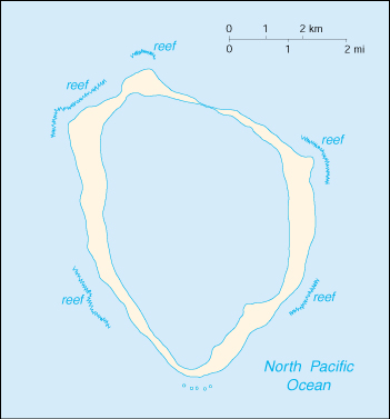
Clipperton
Island
24 Jan
1521
Possibly discovered by Spanish explorer Ferdinand
Magellan that
he named San Pablo.
15 Nov
1528
Reportedly discovered by Spanish Capt. Álvaro de
Saavedra Cerón
(d. 1529) which he names Isla Médanos.
1704
Reportedly discovered by English pirate Captain John
Clipperton
(b. c.1672 - d. 1722).
3 Apr 1711
First documented sighting on the island by French
Capt. Mathieu
Martin de Chassiron (b. 1674 - d. 1722) and
Michel-Joseph Dubocage
(b. 1676 - d. 1727), commanders of the
frigates La Princesse and
La Découverte, who name the
island the Île de la
Passion.
1753
Island appears as Ile de la Passion on the
reduced map of the South
Sea drawn by Frenchman Jacques-Nicolas Bellin.
Aug 1825
American Capt. Benjamin Morrell
(b. 1795 - d. c.1839) makes a
recorded landing on Clipperton.
17 Nov
1858
Annexed
to France by Victor Édouard Le Coat de Kerveguen (b.
1816
- d. 1871)(Île de Clipperton).(subordinated to
French Polynesia).
1892
Claimed as Clipperton Island under the Guano Act by
Frederick W.
Permien (claim rejected by State
Department). In 1893, Permien
transferred his claim to the Oceanic
Phosphate Company.
May 1893 - Oct
1893 Charles
Jensen and "Brick" Thurman of the Oceanic Phosphate
Company
were left on the island to prevent other attempts to
claim the
island and its guano.
1895 - 1905
English and Mexican phosphate
exploitation by the Oceanic
Phosphate
Company.
29 Apr 1897 - Jul 1897
British cargo vessel Kinkora and crew are
wrecked on Clipperton.
13 Dec
1897
Annexed by Mexico
(Isla de la Pasión), remains uninhabited.
Mar 1906 - 18 Jul 1917
Colony settled by Mexico in order to claim Mexican
sovereignty.
8 Jun
1909
France and Mexico decide to arbitrate their
disagreement over
the island's sovereignty.
18 Jul 1917
Surviving islanders are rescued by the USS
Yorktown.
28 Jan
1931
Awarded
to France following the arbitration of
Victor Emmanuel III,
King of Italy (Mexico definitively recognized French
sovereignty
over the island in 1959).
26 Jan
1935
France
re-establishes possession (subordinated
to French
Polynesia).
16 Jun 1936 - 18 Mar 1986 Under the
jurisdiction of the French Establishments of Oceania
and then French
Polynesia.
19 May 1947 - 29 Jun 1947 Capt. William Noble
and crew of fishing boat Thistle from San
Pedro,
California are stranded on the island.
18 Mar 1986 - 21 Feb 2007 Administered by the
High Commissioner for French Polynesia.
22 Dec 1944 - 21 Oct 1945 Occupied by U.S. Navy
during the "Island X" secret operation.
6 Feb 1962 - 1 Mar 1962 Crew
of the tuna clipper M/V Monarch are stranded
on the island
until rescued by the destroyer USS Robison.
6 Jun 1966 - 14 Oct 1968
Clipperton hosts a French scientific mission "Mission
Bougainville".
1982
Exclusive economic zone off Clipperton Island
established by France.
20 Mar 1986
Clipperton becomes a domaine
public de l'État (State-owned
public
domain).
21 Feb 2007 -
Directly administered by the
Minister of Overseas France (who
delegates his powers to High Commissioner
of French Polynesia).
16 Jan
2018
France expands the outer limits of the territorial sea
to 22 km
(12 nmi) and the exclusive economic zone off
Clipperton Island
to 370 km (200 nmi).
21 Feb
2022
The 3DS Loi provided that "the island of
Clipperton may also be
referred to as "La Passion-Clipperton."
Mexican Governors
Mar 1906 - 5 May 1915
Ramón Arnaud
(b. 1879 - d. 1915)
(= Ramón Nonato Arnaud Vignon)
5 May 1915 - 17 Jul 1917
Victoriano Álvarez
(b. 18.. - d. 1917)
(self-declared "king")
U.S. Military Commander
22 Dec 1944 - 23 Oct 1945 George
Lowry
(b. 1889 - d.
1981)
Îles Éparses (Scattered Islands)
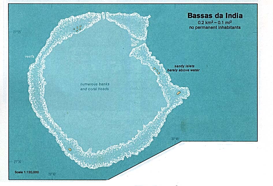
Bassas da India
16th
cent.
Discovered
by Portuguese sailor Gaspar Gonçalves and named Baixo
da India. It is later called Bayos da Indya
(Pilestrina, 1511),
Baxos de la India (Diogo Ribeiro, 1529), Basses
de Judie
(carte de Henri II in 1542), Syrtes Indie
(Sanuto, 1588),
and Basse Juive (De Mannevilette, 1770) .
1825
Named the Bassas da India in a map by British Admiral
William Owen
(b. 1774 - d. 1857).
8 Aug 1896
Claimed by France as part of
French Madagascar
colony.
14 Jun
1960
French
possession; administered by the High
Commissioner
for Reunion (from 19 Sep
1960)(by décret no 60-555 1 Apr 1960).
18 Jan
2005
Transferred
to the administrators of French Southern and
Antarctic Lands.
15 Mar 2007
Incorporated into the French Southern and
Antarctic
Lands.
Territorial Dispute: Claimed
by Madagascar.
Banc du Geyser (Geysir)
c.1650
Shown on Spanish maps as
Arecife de Santo António.
23 Dec 1678
Named Geysir Reef when the English vessel
Geysir ran aground
on the reef.
8 Aug 1896
Banc du
Geyser, a drying reef in the Mozambique Channel,
claimed by France as part of
French Madagascar
colony.
14 Jun
1960
French
possession; administered by the High
Commissioner
for Reunion (from 19
Sep 1960)(by décret no 60-555 1 Apr
1960).
1976
Madagascar
announced the annexation of the reef (no effect).
18 Jan
2005
Transferred
to the administrators of French Southern and
Antarctic Lands.
15 Mar 2007
Incorporated into the French Southern and Antarctic Lands.
22 Feb
2012
Included within the Glorioso Islands Marine Natural
Park.
Territorial Dispute: the
vegetated drying cays of Banc du Geyser, which were
claimed by Madagascar in 1976, also fall within the
EEZ claims of the Comoros and France (Glorioso
Islands).
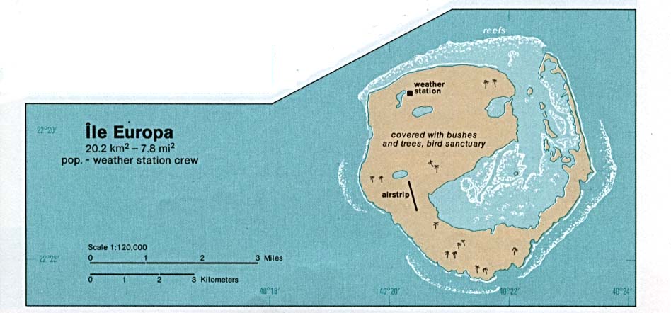
Europa Island
24 Dec 1774
Visited by the British ship Europa.
1825
Named Europa Island in a map by British Admiral
William Owen
(b. 1774 - d. 1857).
c.1860
Frenchman named de Rosiers came to settle the island
from
Madagascar (length of his stay is unknown).
8 Aug
1896
Claimed
by France as part of French Madagascar colony.
31 Oct
1897
Formally annexed to France, part of French Madagascar
colony.
1903
Presence of a small colony is attested.
c.1910
Two couples whose men were said to have been
Seychellois and three
Malagasy employees live on the island.
12 Jan
1950
First meteorological mission landed under the
leadership of Serge
Frolow (b. 1903 - d. 1959).
14 Jun
1960
French
possession administered by the High Commissioner
for Reunion (from 19 Sep
1960)(by décret no 60-555 1 Apr 1960).
1973
France begins garrisoning the island.
18 Jan
2005
Transferred
to the administrators of French Southern and
Antarctic Lands.
15 Mar 2007
Incorporated into the French Southern and
Antarctic
Lands.
Territorial Dispute: Claimed
by Madagascar.
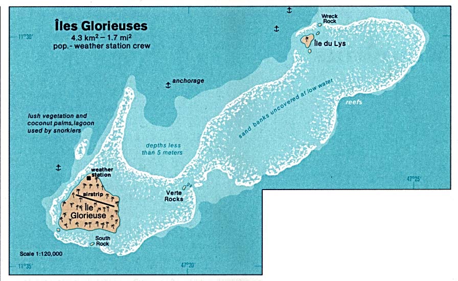
Glorioso Islands
(Îles Glorieuse)
2 Mar
1880
Named and settled by Frenchman Hippolyte Caltaux, who
established
a coconut plantation on Grande Glorieuse.
23 Aug
1892
Claimed
for France by Capt. Richard of the Primauget.
From
1895, subject to French Mayotte.
31 Oct 1897
Formally annexed to France, subject to
Mayotte.
1907
French government ends the
concession of Caltaux.
1907 - 1939
Islands entrusted to the Compagnie
des Îles Malgaches.
1912 - 1960
Mayotte and Glorioso subject to
Madagascar.
May 1945 - 1958
Returned to the Compagnie des
Îles Malgaches.
1959
Permanent meteorological
station established.
14 Jun
1960
French
possession administered by the High Commissioner
for Reunion (from 19 Sep
1960)(by décret no 60-555 1 Apr 1960).
1973
France begins garrisoning the island.
18 Nov 1975
Declared a wildlife reservation.
18 Jan
2005
Transferred
to the administrators of French Southern and
Antarctic Lands.
15 Mar 2007
Incorporated into the French Southern and Antarctic Lands.
22 Feb
2012
Glorioso Islands Marine Natural Park (Parc naturel
marin des
Glorieuses), including Banc du Geyser,
established.
8 Jun
2021
Marine park re-designated National Nature Reserve of
the Glorieuses
Archipelago (Réserve naturelle nationale de
l'archipel des
Glorieuses).
Proprietor (from 1892, Warden)
2 Mar 1880 - 1907
Hippolyte
Caltaux
(b. 1847 - d. af.1927)
Territorial Dispute: Claimed
by Madagascar.
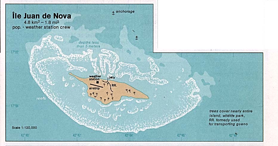
Juan de Nova Island
1501
Discovered by the Portuguese Capt. João da Nova (or
Juan de Nova)
(b. 1460 - d. 1509) and named Galega or Agalega
(Galicia).
It is later called Johan de Nova by Pilestrima
(1519),
Joa de Nova (Mercator, 1569), San-Christophoro
(Ortelius, 1570),
and Saint-Christophe (Lislet Geoffroy).
1825
Named Juan de Nova Island in a map by British
Admiral William Owen
(b. 1774 - d. 1857).
8 Aug 1896
Claimed by France as part of
French Madagascar colony.
31 Dec
1897
Formally annexed to France.
c.1900 - c.1940
Island is rented to a French firm for a 20-year lease
to extract
guano (phosphates) and coconuts.
14 Jun
1960
French
possession administered by the High Commissioner
for Reunion (from 19 Sep
1960)(by décret no 60-555 1 Apr 1960).
10 Mar 1952 -
1968
Leased by France to Société française des îles
Malgaches (SOFIM)
to extract phosphate for a period of 15 years
(reappointed for
25 years on 15 Jun 1960).
1963
Installation of an auxiliary meteorological named la
Goulette.
1974
France begins garrisoning the island.
18 Jan
2005
Transferred
to the administrators of French Southern and
Antarctic Lands.
15 Mar 2007
Incorporated into the French Southern and
Antarctic
Lands.
Territorial Dispute:
Claimed by Madagascar.
Tromelin Island
Aug
1722
Discovered the
French ship of the Compagnie française
des Indes
orientales, the Diane,
commanded by Jean Marie Briand de la
Feuillée (b. 1685 - d. 1739) and named Île
de Sable
(Isle of Sand).
1 Aug 1761 - Oct 1761
French ship L'Utile,
of the Compagnie française des Indes
orientales,
shipwrecks on the island with its crew and slaves.
29 Nov
1776
French Capt. Jacques-Marie Boudin de Tromelin,
chevalier de
Tromelin (b. 1751 - d. 1798) on the
corvette La Dauphine rescues
the remaining slaves of L'Utile
on the island who are taken to
Mauritius and freed.
1814
Placed under the jurisdiction of Reunion.
1825
Named Tromelin Island in a map by British Admiral
William Owen
(b. 1774 - d. 1857).
26 Nov 1867 - 22 Dec 1867 Indian ship Atieth
Rahamon commanded by Capt. Samuel
C. Hodges
with its crew is wrecked on the island.
8 Aug 1896
Part
of French Madagascar colony.
1954
France begins garrisoning the island.
14 Jun
1960
French
possession; administered by the High
Commissioner
for Reunion (from 19 Sep 1960)(by décret
no 60-555 1 Apr 1960).
18 Jan
2005
Transferred
to the administrators of French Southern and
Antarctic Lands.
15 Mar 2007
Incorporated into the French Southern and Antarctic Lands.
Territorial Dispute: Claimed
by Mauritius.
© Ben Cahoon
|