U.S. Unincorporated Possessions
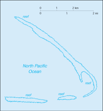
Bajo Nuevo Bank (Petrel Islands)
1634
Reef first shown on Dutch maps.
1654
Named Bajo Nuevo Bank.
1660
Re-discovered by the English.
22 Nov 1869
Claimed
by U.S. by James W. Jennett (also called
Petrel Islands).
8 Sep 1972
Bajo Nuevo is
specifically not mentioned by U.S. in list of
guano
islands renounced to Colombia.
20 Dec
1999
Maritime Delimitation Treaty between Honduras and
Colombia ratified
by Honduras. Honduras recognizes Colombia
sovereignty over
Serranilla Bank and nearby Bajo Nuevo.
Territorial Disputes:
Colombia, Nicaragua, Jamaica, and the U.S. assert
various claims to Bajo Nuevo; Colombia considers Bajo
Nuevo Bank a part of the Providence Archipelago in the
intendancy of San Andres y Providencia; Nicaragua
disputed Honduras's legal right to hand over these
areas before the ICJ.
Baker Island
-
![[Unofficial
Flag the Baker, Howland and Jarvis Islands
(U.S.)]](us-baker.gif "[Unofficial Flag the Baker,
Howland and Jarvis Islands (U.S.)]") Baker,
Howland, & Jarvis Islands Flag Baker,
Howland, & Jarvis Islands Flag
- From 4 Jul 2017 Unofficial
|
|
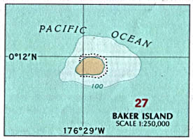
Map
of
Baker Island
|
Population:
Uninhabited;
visited annually by US
Fish
and Wildlife Service
Capital: None
(Meyerton 1935-1942)
|
1818
Discovered by U.S.
Capt. Elisha Folger of the whaling ship Equator,
named New Nantucket Island.
Aug 1825
Re-sighted by U.S. Capt.
Obed Starbuck of the Loper.
1832
Renamed by Baker Island by U.S. Capt. Michael
Baker.
14 Aug
1839
Claimed
for the U.S.
16 Aug
1857
Annexed
by U.S.
1886 -
1934
Annexed
by Britain.
2 Apr 1935 - 31 Jan 1942
Colonized by U.S. (under Department of Commerce to 13
May 1936).
13 May
1936
Formally claimed by U.S. (unincorporated territory).
13 May 1936 - 27 Jun 1974 Administered
by U.S. Department of the Interior.
1 Sep 1943 - May
1944 Occupied by U.S. military
forces (Baker Naval Air Station).
27 Jun
1974
Administered
by U.S. Fish & Wildlife Service (Baker
and
Howland Islands National Wildlife Refuge).
6 Jan 2009
Part of
Pacific Remote Islands Marine National Monument.
Heads of the Baker, Howland and Jarvis
Islands Colonization Scheme (in
U.S.)
Mar 1935 - May 1936
William T. Miller
(Superintendent of Airways Bureau of
Air Commerce,
U.S. Department of Commerce)
May 1936 - Feb
1942 Richard
Blackburn Black
(b.
1902 - d. 1992)
(field representative Division of Territories
and Island Possessions)
Island Leaders
2 Apr 1935 - 18 Apr 1935
Carl
Summers
Mil
19 Jun 1935 - 19 Jan 1936 Abraham
Piianaia (1st time)
(b. 1915 - d. 2003)
19 Jan 1936 - 18 Jun 1936
Herbert Hooper
18 Jun 1936 - 26 Oct 1936 Abraham
Piianaia (2nd time) (s.a.)
26 Oct 1936 - 24 Jun 1937
Albert K. Akana
(b. 1917 - d.
2004)
24 Jun 1937 - 17 Nov 1937
Charles A. Ahia
17 Nov 1937 - 23 Jul 1938 Theodore Akana
23 Jul 1938 - 1 Dec 1938 Edward
Mike
McCorriston
(b. 1917 - d. 2005)
2 Dec 1938 - 20 Mar 1939 Bernard
Akana
20 Mar 1939 - 10 Mar 1940 Louis
Suares
(b. 1915 - d. 1997)
10 Mar 1940 - 24 Jul 1940 Melvin
Paoa
(b. 1914 - d. 1987)
24 Jul 1940 - 25 Mar
1941 Karl Jensen
25 Mar 1941 - 28 Jul 1941 Ernest W.
Rankin
28 Jul 1941 - 31 Jan 1942
Walter Burke
U.S. Island Commanders
1 Sep 1943 - 1943
Edward Aiken
Flanders
(b. 1917 - d. 1995)
(804th Aviation Engineer Battalion)
c.1943
W.J.
Jennings
1943 - May
1944
....
Guantanamo Bay: see under Cuba
Howland Island
- Baker,
Howland, & Jarvis Islands Flag
- From 4 Jul 2017 Unofficial
|
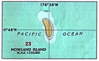
|
Map
of
Howland Island |
Population: Uninhabited;
visited annually by US
Fish
and Wildlife Service
Capital: None
(Itascatown 1935-1942) |
1822
Discovered by U.S. Capt. George B. Worth on whaling
ship Oeno
named Worth Island.
9 Sep
1842
Re-sighted
by U.S. Captain George Netcher aboard Isabella
and renamed
Howland Island for the ship's lookout,
Mr. Howland, who first
spotted the island.
5 Feb
1857
Annexed
by U.S.
1886 - 1935
Claimed
by Britain.
30 Mar 1935 - 31 Jan 1942 Colonized by
U.S. (under Department of Commerce to 13 May
1936).
13 May
1936
Formally claimed by U.S. (unincorporated territory).
13 May 1936 - 27 Jun 1974 Administered
by U.S. Department of the Interior.
2 Jul 1937
Amelia Earhart left Lae,
New Guinea, headed for Howland Island,
but is never seen again.
Sep 1943 - May
1944
Occupied by U.S. military forces (Howland Naval Air
Station).
27 Jun
1974
Administered
by U.S. Fish & Wildlife Service (Baker
and Howland Islands National Wildlife Refuge).
6 Jan 2009
Part of
Pacific Remote Islands Marine National Monument.
Island Leaders
30 Mar 1935 - 18 Apr 1935 Henry
Theise
Mil
19 Jun 1935 - 19 Jan 1936 James C.
Kamakaiwi (1st time)
19 Jan 1936 - 6 Aug 1936
Joseph Anakalea
6 Aug 1936 - 26 Oct 1936 Killarney
Opiopio
(b. 1913 - d. 1977)
26 Oct 1936 - 25 Jun 1937 James
C. Kamakaiwi (2nd time)
25 Jun 1937 - 16 Nov 1937 William Kaina
16 Nov 1937 - 23 Mar 1938 Charles
Ahia
23 Mar 1938 - 30 Nov 1938 James Kinney
30 Nov 1938 - 21 Mar 1939 William Tavares
21 Mar 1939 - 10 Jun 1939
Eugene Burke
10 Jun 1939 - 12 Oct 1939 Thomas
McCorriston
12 Oct 1939 - 9 Mar 1940 Francis
Stillman
9 Mar 1940 - 23 Jul 1940 Edward
"Mike" McCorriston
(b. 1917 - d. 2005)
23 Jul 1940 - 27 May 1941 Louis Suares
(b. 1915 - d. 1997)
27 May 1941 - 31 Jan
1942 Thomas Wright Bederman
(b. 1921 - d.
1999)
U.S. Island Commanders
Sep 1943 - May
1944 ....
Jarvis Island
- Baker,
Howland, & Jarvis Islands Flag
- From 4 Jul 2017 Unofficial
|
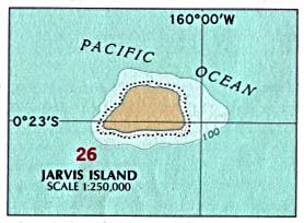
|
Map
of
Jarvis Island
|
Population:
Uninhabited;
visited annually by US Fish
and Wildlife Service
Capital: None
(Millersville 1935-1942)
|
21 Aug
1821
Discovered
by U.K. Capt. Brown in the Eliza Francis,
who named
it Jarvis Island for the owner of the
vessel.
28 Oct 1856
Claimed for U.S.
27 Feb
1858
Annexed
by U.S.
3 Jun
1889
Annexed
by Britain.
25 Mar 1935 - 9 Feb 1942
Colonized by U.S. (under Department of Commerce to 13
May 1936).
13 May 1936
Formally claimed by U.S. (Javis Island)(unincorporated
territory).
13 May 1936 - 27 Jun 1974 Administered
by U.S. Department of the Interior.
1 Jul 1957 - 31 Dec 1958 Occupied
by U.S. scientists during International
Geophysical Year (IGY).
27 Jun
1974
Administered
by Department of Interior under Fish & Wildlife
Service
(Jarvis Island National Wildlife
Refuge).
6 Jan 2009
Part of
Pacific Remote Islands Marine National Monument.
Island Leaders
25 Mar 1935 - 22
Apr 1935 Austin
Collins
Mil
15 Jun 1935 - 15 Jan 1936 Henry Ahia (1st
time)
15 Jan 1936 - 19 Jun 1936 Edward Young
19 Jun 1936 - 30 Jul 1936 Henry Ahia (2nd
time)
30 Jul 1936 - 18 Jan 1937 Solomon Kalama
(b. 1913 - d. 1993)
18 Jan 1937 - 31 Oct 1937 Joseph Kim
31 Oct 1937 - 8 Aug 1938 Albert
Akana
8 Aug 1938 - 11 Dec 1938 Alexander
Wong
11 Dec 1938 - 30 Mar 1939 Francis Lee
30 Mar 1939 - 15 Jun 1939 George Akana
15 Jun 1939 - 1 Aug 1940 James
Kinney
1 Aug 1940 - Nov
1941 Henry K. Lee
Nov 1941 - 9 Feb
1942 Karl E. Jensen
Station Chief for IGY
1957 - 11 Oct
1958
Otto H. Hornung, Jr.
(b. 1902 - d. 1958)
Johnston Atoll
-
![[Johnston Atoll
unofficial flag (U.S.)]](um-jq.gif "[Johnston
Atoll unofficial flag (U.S.)]") Adopted 2 Nov
2001 Unofficial Adopted 2 Nov
2001 Unofficial
|
2 Sep
1796
U.S. brig Sally, commanded
by Joseph Pierpoint, grounded on a shoal
near Johnston Island, but gave no name to
the land.
10 Dec
1807
Re-discovered
by U.K. Capt. Charles J. Johnston on HMS
Cornwallis,
named Johnston Island.
19 Mar
1858
Claimed
by U.S. (unincorporated territory).
19 Jun
1858
Claimed
by Kingdom of Hawaii (Kalama Island).
27 Jul
1858
Annexed
by U.S.; re-annexed by Hawaii (not recognized by
U.S.).
12 Aug
1898
Hawaii
under U.S. rule; Johnston remains separate.
29 Jul 1923
Administered
by U.S. Department of Agriculture as a bird refuge.
29 Dec 1934 - 1 Jul 1948
Administered by U.S. Navy Department, subject to
Department of
Interior.
15 Aug 1941 - 13 Jun 1947 Naval Air
Station Johnston Island (from Feb 1947, Naval Air
Facility
Johnston Island)
12 Dec
1941
Japanese submarine surfaces 8,000 yards off Sand
Island and
began firing green star clusters which exploded high
overhead.
15 Dec
1941
Two Japanese ships opened fire, damaging a number of
buildings and
an oil storage facility.
18, 21, 22 Dec
1941
Japanese submarines return at night firing
sporadically at the
Marine defenders.
1 Jul
1948
Administered
by U.S. Air Force Department (Johnston Island Air
Force
Base).
1 Jul
1973
Administered
by the U.S. Defense Nuclear Agency (later called
Defense Threat Reduction Agency).
30 Jun 1990 - 12 Apr 2001 U.S. Army
Johnston Atoll Chemical Agent Disposal System (JACADS).
1 Oct 1999 - 1 Jan 2004
Administered by U.S. Air Force.
1 Jan
2004
Island
turned over to Department of Interior's Fish and
Wildlife
Service (Johnston Atoll
Wildlife Refuge); in the interim Johnston
Atoll and the three-mile Naval
Defensive Sea around it remain under
the jurisdiction and administrative control of U.S.
Air Force.
6 Jan 2009
Part of Pacific Remote
Islands Marine National Monument.
U.S. Island
Commanders (16th Defense
Battalion 15 Nov 1942 - 16 Apr 1944)
9 Nov 1939
- 1941
....
7 Dec 1941 - 1942
Francis Butler Loomis, Jr.
(b. 1903 -
d. 1989)
(executive officer, Marine 1st Defense Battalion)
1942 - Nov
1942
James Marvin
Masters
(b. 1911 - d. 1988)
15 Nov 1942 - 5 Jul 1943 Richard
Potts Ross, Jr.
(b. 1906 - d. 1990)
6 Jul 1943 - 14 Mar 1944 Bruce
Tillman Hemphill
(b. 1912 - d. ....)
15 Mar 1944 - Aug 1944
August F. Penzold, Jr.
(b. 1913 - d. 1980)
c.1948 - c.1949
Thomas L. Wiper
(b. 1916 - d. 2005)
1950s
Jack
L. Bentley
1944 - 2000
....
2000 -
2001
James
L. Pasquino
(b. c.1955)
c.2002
Timothy
Bridges
5 Aug
2003 - 200.
Mark Hostetter
200. -
2004
Eric
Sassi
Kingman Reef
-
![[Kingman
Reef unofficial flag (U.S.)]](us-kingman.gif "[Kingman Reef unofficial flag
(U.S.)]") From
4 Jul 2017 Unofficial From
4 Jul 2017 Unofficial
|
14 Jun
1798
Discovered by U.S. Capt. Edmund Fanning
(Dangerous Reef).
29 Nov
1853
Re-sighted
by U.S. Capt. W.E. Kingman.
18 Aug
1856
Claimed
by U.S. (Danger Reef)
10 May
1922
Annexed
by U.S. (Kingman Reef)(unincorporated
territory).
29 Dec
1934
Administered
by U.S. Navy Department.
18 Jan
2001
Administered
by Department of Interior under Fish & Wildlife
Service
(Kingman
Reef National Wildlife Refuge).
6 Jan 2009
Part of Pacific Remote
Islands Marine National Monument.
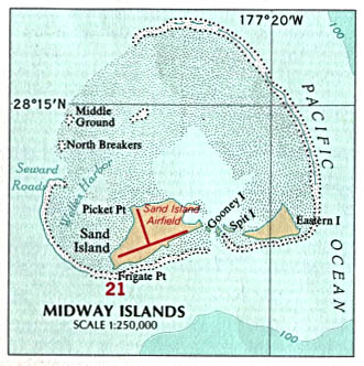
Midway Islands
-
![[Midway
Islands unofficial flag (U.S.)]](us-midway.jpg "[Midway Islands unofficial flag
(U.S.)]") Adopted
4 Jun 2000 Unofficial Adopted
4 Jun 2000 Unofficial
|
8 Jul
1859
Discovered
by U.S. Capt. N.C. Middlebrooks, though he was most
commonly known as Capt. Brooks, of the
sealing ship Gambia.
Islands named the "Middlebrook Islands"
or the "Brook Islands.
28 Aug
1867
Annexed
for U.S. by Capt. William Reynolds on U.S.S.
Lackawanna,
the name changed to "Midway" some time after this
(unincorporated territory).
20 Jan 1903
U.S. Navy Department
assumes control and names the Commercial Pacific
Cable Company as island custodians on 20
Jun 1903. The Secretary of
the Navy designated the Commander-in-chief of the
Pacific Fleet
to act as its administrative authority.
1904 -
1908
U.S.
Marine detachment garrisons Midway to protect the
cable
station.
27 Mar 1940 - 31 Oct 1996 Administered
by the U.S. Navy Department.
1 Aug 1941
U.S.
Naval Air Station Midway
4-7 Jun 1942
Battle of Midway,
attempted Japanese invasion.
29 Jul 1942
U.S. Naval Operating Base Midway
Islands
6 Jun 1950 - Sep 1950
Naval base deactivated, only Commercial Pacific
Cable remains.
31 Dec
1952
Commercial Pacific Cable turns over
assets to Navy.
Apr 1953 - Jul
1953 Naval
base again deactivated.
4 Sep
1962
Executive Order 11048 makes the Secretary of the Navy
responsible for
the civil administration of Midway.
13 Jan 1969
U.S. Naval Facility
Midway Island
Mar
1971
Eastern Island vacated and designated a wildlife
habitat.
Oct 1978 - 30 Sep 1983
U.S. Naval Air Facility Midway Island
22 Apr 1988
Midway Atoll is designated
as an Overlay National Wildlife Refuge.
30 Sep
1993
Naval Air Facility Midway is operationally closed,
last U.S. Navy
personnel depart 30 Jun 1997.
31 Oct
1996
Administered
by the Department of Interior under U.S. Fish &
Wildlife
Service (Midway Island National
Wildlife Refuge).
13 Sep
2000
Battle of Midway National Memorial designated.
15 Jun
2006
Midway included within the Papahānaumokuākea Marine
National
Monument in the Northwestern Hawaiian Islands (28 Feb
2007, renamed
Papahānaumokuākea Marine National
Monument).
11 Mar
2011
A 1.5 Meter (4.9 FT) high wave, caused by the 2011
Sendai earthquake
in
Japan, completely submerged the atoll's reef inlets
and Spit
Island.
Superintendents of the Commercial Pacific Cable
Company Station, Midway
29 Apr 1903 - 1906?
Benjamin W.
Colley
1906 -
1921
Daniel
Morrison
1921 - 27 Mar 1940
....
6 Jun 1950 - Sep 1950
....
U.S. Island Commanders (commander
Midway Naval Air Station from 1 Aug 1941)
27 Mar 1940 -
1940
D.B. Ventries (officer in charge)
Jun 1940 - Jul
1940 Samuel
G.
Taxi
(b. 1909 - d. 1984)
Jul 1940 - 29 Sep
1940 Kenneth Wachter
Benner
(b. 1904 - d. 1975)
29 Sep 1940 - 14 Feb 1941
Harold Cyrus Roberts
(b. 1898 - d. 1945)
14 Feb 1941 - 1941
Robert H. Pepper
(b. 1895 –
d. 1968)
1941 - 18 Aug
1941
Bertram "Bert" Allison
Bone (b.
1893 - d. 1961)
18 Aug 1941 - Jul/Sep 1942 Cyril Thomas
Simard
(b. 1895 – d. 1976)
Jul/Sep 1942 - 30 Jun 1997
....
Commanders, Marine 6th Defense Battalion
15 Mar 1941 - 14 Oct 1941 Raphael Griffin
(arrives Sep 1941)
15 Oct 1941 - 5 Aug 1942 Harold Douglas
Shannon
(b. 1896 - d. 1943)
6 Aug 1942 - 9 Sep 1942 Lewis A.
Hohn (1st time)
(b. 1907 - d. 1967)
10 Sep 1942 - 26 Oct 1942 Rupert
R. Deese
27 Oct 1942 - 3 Nov 1942 Robert
E. Hommel
4 Nov 1942 - 3 Nov 1943 Lewis A.
Hohn (2nd
time)
(s.a.)
4 Nov 1943 - 25 Dec 1943 John Houghton
Griebel
(b. 1901 - d. 1969)
26 Dec 1943 - 27 Mar 1944 Charles
T. Tingle
28 Mar 1944 - 30 Dec 1944 Frank
P. Hager, Jr.
31 Dec 1944 - 29 Apr 1945 Robert
L. McKee
30 Apr 1945 - 1 Jul 1945 Herbert
R. Nusbaum
2 Jul 1945 - 4 Oct 1945 Wilfred
Weaver
5 Oct 1945 - 24 Jan 1946 Bruce
F. Hillman
25 Jan 1946 - 1 Feb 1946 George R.
Helmer
Navassa Island
-
![[Navasa
Island unofficial flag (U.S.)]](um-navsa.gif "[Navasa Island unofficial flag
(U.S.)]") Adopted
7 Dec 2001 Unofficial Adopted
7 Dec 2001 Unofficial
|
|
Map
of
Navassa Island
|
Population:
Uninhabited;
note: transient
Haitian
fishermen and others camp
on the island
|
1504
Discovered by Spanish explorers, named Isla de Navaza.
18 Nov
1857
Claimed
for U.S. by Capt. Peter Duncan (Navassa Island)
(unincorporated territory).
5 Aug 1869 - 12 Jan 1889 Under
Navassa Guano Company of Wilmington, North Carolina.
12 Jan 1889 -
1898
Under Navassa Phosphate Company of Baltimore,
Maryland.
2 May 1891 - 20 Jun 1891 U.S.S.
Kearsarge lands a party of Marines on the
island.
1898
All phosphate operations abandoned,
island becomes uninhabited.
1903 -
1917
Dependency
of U.S. Guantanamo Bay Naval Base.
17 Jan
1916
U.S.
government formally reasserts sovereignty.
21 Oct 1917 - 1 Jul 1939
Administered by U.S. Lighthouse Service (Lighthouse
is automated
1929, dismantled 29 Aug 1996).
1 Jul 1939 - 16 Jan 1997 Administered
by U.S. Coast Guard.
16 Jan 1997 - 3 Dec 1999
Administered by U.S. Department of Interior.
3 Dec
1999
Administered
by U.S. Fish & Wildlife Service (Navassa
Island National Wildlife Refuge).
Territorial Dispute:
Haiti claims U.S.-administered Navassa Island,
the dispute dates to 1857, when the U.S. claimed the Navassa
Island under the 1856 Guano Act; Haiti claims
it has had ownership over Navassa Island continuously
since its 1801 constitution laid claim to "adjacent
lands."
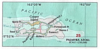
Palmyra Atoll
-
![[Palmyra
Atoll (reconstructed World War II) flag
1941-1947 (U.S.)]](um-palmy.gif "[Palmyra Atoll
(reconstructed World War II) flag 1941-1947
(U.S.)]")
- 1941 - 1947 Unofficial
|
-
![[Palmyra
Atoll unofficial flag (U.S.)]](um-plmyr.gif "[Palmyra Atoll unofficial flag
(U.S.)]")
- Adopted 7 Dec 2001
Unofficial
|
13 Jun
1798
Probably
sighted by U.S Capt. Edmund Fanning aboard the Betsy.
7 Nov
1802
Discovered
by U.S. Capt. Sawle aboard U.S.S. Palmyra,
named
Palmyra Island.
15 Sep
1840
Visited
by U.S. Capt. Scott aboard the Samarang.
19 Oct
1859
Gerrit P. Judd landed from the brig Josephine
and laid claim to
Palmyra for the American Guano Co., for which
he was agent.
Apparently this claim never was recognized at
Washington and no
guano was dug.
15 Apr
1862
Claimed
for Kingdom of Hawaii
by Capt. Zenas Bent.
18 Jun
1862
Annexed by Kingdom of Hawaii.
1889
Commander
Nichols of the British ship HMS Cormorant
claimed Palmyra
for the United Kingdom, unaware of the prior
claim by Hawaii.
12 Aug
1898
Palmyra annexed to the U.S. along with the overall
annexation of
the Hawaiian Islands.
14 Jun
1900
Part
of the U.S. Territory of Hawaii.
30 Apr 1912
Judge Henry E. Cooper of
Honolulu acquired title to the island.
He sold all but two islets to
Leslie and Ellen Fullard-Leo on 19
Aug 1922 for $15,000.
who establish the Palmyra Copra Company.
When Cooper dies 14 May 1929 his
two islets (Home Islands) were
passed to his
heirs.
21 Feb
1912
U.S.
formally reaffirms American claim
(as part of Hawaii).
21 Oct 1912
U.S. sovereignty reaffirmed by Admiral W.H.
Southerland aboard the
U.S.S. West Virginia.
29 Dec 1934
Administered by U.S. Navy Department.
Nov 1939
Palmyra declared a U.S. Naval defense
area, and all foreign, public
and private vessels and planes
were prohibited.
17 Aug 1941 - 15 Feb 1947 Naval Air
Station Palmyra Island (transferred to the Coast Guard
on
16 Jan 1946).
24 Dec
1941
Japanese submarine surfaced 3,000 yards offshore
firing its deck guns
at a dredge located in the lagoon.
12 May 1947
U.S. Supreme Court restores Palmyra to
the Fullard-Leo family.
21 Aug
1959
Hawaii
becomes a state; but Palmyra is excluded and
remains as an
incorporated territory, administered by U.S.
Department of
of Interior.
10 Oct
1961
Executive Order restated that the
Secretary of the Interior was
vested with the civil administration of Palmyra.
20 Nov
2000
Palmyra
Atoll purchased by the Nature Conservancy for about
$30
million. The Conservancy
manages the atoll as a nature preserve.
18 Jan
2001
Palmyra's tidal lands, submerged lands, and
surrounding waters out to
12 nautical miles from the water's
edge declared as a National
Wildlife Refuge under the U.S. Fish &
Wildlife Service
(Palmyra Atoll National Wildlife Refuge).
Mar
2003
The Nature Conservancy conveyed 416 acres of
the emergent land of
Palmyra to the U.S. to be included
in the refuge. It subsequently
added 28 more acres to the conveyance.
6 Jan 2009
Part of
Pacific Remote Islands Marine National Monument.
25 Sep
2014
Pacific Remote Islands Marine National
Monument expanded.
U.S. Island Commanders
Nov 1939 - 1941
....
1941 - af.Jul 1942
Gordon Rowe
(b.
1890 - d. 19..)
Dec 1941 - May 1942
Bertram
"Bert" Allison
Bone
(b. 1893 - d. 1961)
(commander Marine
1st Defense Battalion)
Jul 1942 - 1? Feb
1943 J.R. Dudley
bf.1May 1943 - Nov 1943 R.N. Hunter
Nov 1943 - 1944?
Bert Haddow Creighton
(b. 1897 - d. 1975)
Sep 1944 - Sep? 1945
Walter M. Hanson
Sep? 1945 - 15 Feb 1947 ....
Serranilla Bank
1510
Serranilla Bank first shown on Spanish maps.
8 Sep 1879
Claimed
by the U.S (located two hundred ten miles north
northeast of Nicaragua).
8 Sep 1972
Serranilla
Bank specifically not mentioned by
U.S. in list of guano
islands renounced to Colombia.
20 Dec
1999
Maritime Delimitation Treaty between Honduras and
Colombia ratified
by Honduras. Honduras recognizes Colombia sovereignty
over
Serranilla Bank and nearby Bajo Nuevo.
Territorial Disputes:
Colombia, Nicaragua, Jamaica, and the U.S. assert
various claims to Serranilla Bank; Colombia considers
Serranilla Bank a part of the
Providence Archipelago in the intendancy of San Andres
y Providencia; Nicaragua disputed Honduras's legal
right to hand over these areas before the ICJ;
Nicaragua filed a case with the International Court of
Justice (ICJ) against Colombia in 2013 over the
delimitation of the Continental shelf beyond the 200
nautical miles from the Nicaraguan coast, as well as
over the alleged violation by Colombia of Nicaraguan
maritime space in the Caribbean Sea, which contains
rich oil and fish resources; as of Sep 2021, Colombia
refuses to abide by the ICJ ruling.
Wake Island: see separate Wake Island page
© Ben Cahoon
|