|
WORLD
STATESMEN.org
|
Self-Proclaimed Micronations
Note: This page is about a
small number of entities that are mostly historical
anomalies and aspirant states founded on historical
anomalies or eccentric interpretations of law. This
page is about entities that are not recognized by
world governments or major international
organizations. For information on countries that are
generally recognized, but are geographically tiny such
as Nauru, Vatican City, or San Marino, see
microstates. Micronations – sometimes also referred to
as cybernations, fantasy countries, model countries,
and new country projects – are entities that resemble
independent nations or states, but for the most part
exist only on paper, on the Internet, or in the minds
of their creators. Some micronations have managed to
extend some of their operations into the real world:
examples of this may include currency, flags, postage,
etc. These trappings of the more widely accepted
nations and states of the "real world" may serve to
enhance the suspension of disbelief for people both
inside and outside of the micronations in question.
The term "micronation" is a
neologism originating in the 1990's to describe the
many thousands of small, unrecognized state-like
entities that have arisen mostly since that time. The
term has since also come to be used retroactively to
refer to earlier unrecognized entities, some of which
date as far back as the 19th century. In recent years
the term "micropatrology" has been used by some to
describe the study of micronations; it is not a formal
academic discipline.
Micronations should be
distinguished from various entities which exercise
effective governmental and military control over a
territory, despite not being recognized as a state by
most or all other states. Examples of such entities
would include South Ossetia, Abkhazia, and
Transnistria, or many parts of the world controlled by
rebel guerrilla groups. By contrast, micronations do
not exercise effective military or governmental
control of any more than a very small area (e.g. the
private property of its founders), if that. These
criteria distinguish micronations from imaginary
countries, eco-villages, campuses, tribes, clans,
sects, and residential community associations, which
do not usually seek to be recognized as sovereign.
Micronations should also be distinguished from
entities that have diplomatic relations with other
recognized nation-states of the world without being
formally recognized themselves by many nation-states
or major international bodies (such as the UN).
Examples of this include Taiwan, Tibet, and Palestine.
By contrast, micronations do not generally have
diplomatic relations with recognized nation-states of
the world or major international bodies (such as the
UN).
Disclaimer: This page does
not formally recognize, support or endorse these
polities or any money making schemes they
operate.
Hutt River
-
![[Principality
of Hutt River flag 1907-2020 (Western
Australia)]](au-hrpp.gif "[Principality of Hutt
River flag 1970-2020 (Western Australia)]")
- 1970 - 3 Aug 2020
|
|
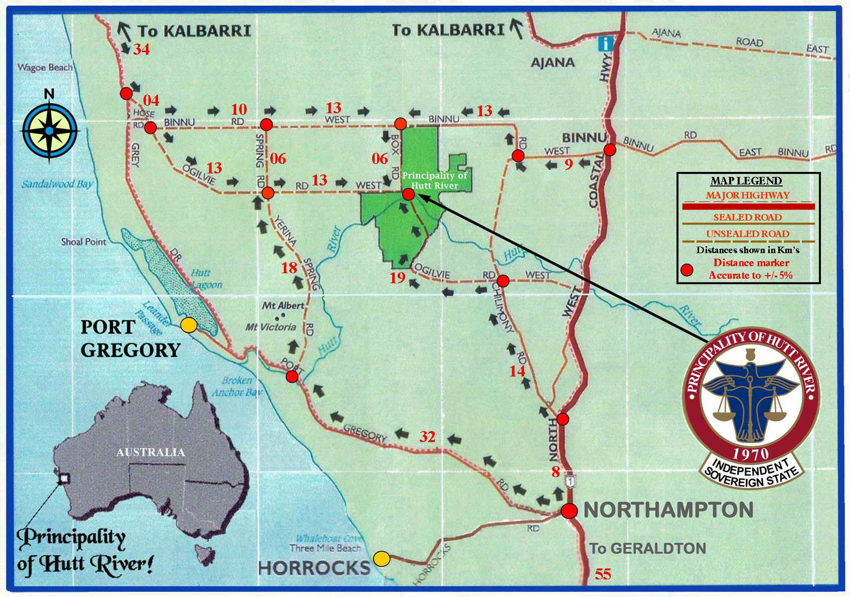
Map
of Hutt River
|
Hear
National Anthem
"Hutt River
National Anthem"
(a.k.a. "It's a Hard Land")
|
Text
of National Anthem
Adopted 1984
|
Constitutions
(1
Oct 2005; 10
Oct 2015)
|
Capital:
Nain
( 2704 Ogilvie West Road,
Yallabatharra, WA)
|
Currencies:
Hutt River Dollar;
Australian Dollar (AUD)
|
National
Holiday: 21 Apr (1970)
Independence Day
|
Population:
30 (2017)
23 (2011)
|
|
GDP: $N/A
|
Exports:
$N/A
Imports: $N/A
|
Ethnic groups:
European, Aboriginal
|
|
Total Armed
Forces: None
|
Religions:
Anglican, other
|
| International
Organizations/Treaties: None |
|
Hutt
River
|
Chronology
21 Apr
1970
Province of Hutt River; declares
secession from
the State of Western
Australia and
from Australia
(not formally recognized by
Australia or Western Australia).
1970
Hutt River
Province Principality
15 Feb 1977
Despite Casley's claims
to sovereignty, he was
successfully prosecuted
for failing to comply
with requirements to furnish the
Australian
Taxation Office (ATO)
with required documents.
23 Nov
1977
George F. Hamm laid claim to part of
Antarctica in
the name of the Sovereign
of Hutt River while on
on the Qantas 707 South
Magnetic Pole flight.
1 Oct 2005
Principality of Hutt River Province
12 Sep 2006
Principality of
Hutt River
9 Jun 2017
Casley is ordered by the Supreme Court
of Western
Australia to pay $2.7
million in unpaid tax, and
his son Arthur Casley was
ordered to pay
$242,000 in unpaid tax.
31 Jan
2020
Suspends all government external
services and
closes the border due to the Covid-19
pandemic.
3 Aug 2020
Announcement that the
government will dissolve and
once again
become part of Western Australia
amidst disputes with the
Australian Taxation
Office and the financial
effects of COVID-19.
11 Apr 2021
Cyclone Seroja devastated
the Principality.
Sep
2021
Hutt River Province land sold to a
local farmer
for less than the $3.3
million-plus claimed by
the Australian Tax
office.
|
|
Hutt
River website
|
| |
| |
| |
| |
|
Administrator
21 Apr 1970 -
1970
Leonard
(b. 1925 - d. 2019)
(= Leonard George Casley)
Princes¹
1970 - 11 Feb 2017
Leonard
I
(s.a.)
11 Feb 2017 - 3 Aug 2020 Graeme I (=
Graeme Ernest Casley) (b. 1957)
Prime ministers (Ministers of State)
.... - 11 Feb
2017
Prince Graeme
(s.a.)
2017? - 14 Jun 2020
Prince Ian (= Ian George Casley)
(b. 1947 - d. 2020)
¹style of the rulers: "His
Royal Highness, The Prince of Hutt."
Territorial Dispute: 'independence'
was never recognized by Australia or any other nation.
note: The Australian
government unequivocally stated that it did not
recognize the secession of the principality. Leonard
Casley (s.a.) settled as a farmer in Western Australia
in 1969. Outraged by the low wheat allotment sent him
by the Australian government that year, Casley seceded
and formed the independent Hutt River Province. Hutt
River Principality was situated 595 km north of Perth,
Western Australia and is about 75 square km in size,
consisting of some 18,500 acres of land. Hutt River
declared it was an independent sovereign state having
seceded from Australia on 21 Apr 1970 and is of
comparable size to Hong Kong (not including the New
Territories). The principality had no legal status as
a matter of Australian law. In 2007, the High Court of
Australia dismissed an application by Casley for leave
to appeal against a judgment against him relating to
his son Leonard's failure to file tax returns. Leonard
argued that he resided in the "Hutt River Province"
and that it is not part of Australia and not subject
to Australian taxation law. The court dismissed
Casley's application and found that his arguments were
"fatuous, frivolous, and vexatious."
Minerva: see under Tonga
Outer Baldonia
|
![[Principality of
Outer Baldonia flag 1949-1973 (Nova Scotia,
Canada)]](ca_ns-ob.gif "[Principality of Outer
Baldonia flag 1949-1973 (Nova Scotia,
Canada)]")
1949 - 28 Dec 1973
|
| Map of Outer Baldonia
|
Hear National
Anthem |
Text of
National Anthem
|
State Charter
(1949-1973)
|
| Capital:
Royal Palace |
Currency:
Tunar;
Canadian Dollar (CAD) |
National
Holiday: N/A
|
Membership:
69 |
GDP: $N/A
|
Exports: $N/A
Imports: $N/A
|
Ethnic
groups: White
|
Total
Naval Force: 69
|
Religions:
N/A
|
International
Organizations/Treaties: None
|
|
Outer Baldonia
|
Chronology
1948
Outer Bald Tusket Island, 8 nautical
miles off the
southernmost extremity
Nova
Scotia, Canada, is
purchased by Russell
Arundel for $750 from local
fishermen Élie Cottreau and Ida
Doucette.
1949
Principality of Outer Baldonia
declared independent
9
Mar 1953
Declares
war on Soviet Union in response to
negative press in the Literaturnaya
Gazeta.
28 Dec 1973
Sold
by Arundel for $1 to the Nature
Conservancy of
Canada. Is is now under the Nova
Scotia Bird
Society. The island was
designated as the Earle
E.
Arundel Breeding Bird Sanctuary.
9 May 2016
Stewardship of the island is
transferred to the
Nova
Scotia Nature Trust.
|
|
| |
| |
|
|
| |
|
Prince (styled Prince of Princes)
1949 - 28 Dec 1973
Russell M. Arundel ("Russell Rex I")(b. 1902 - d. 1978)
Chancellor
1949 -
19..
Elson Boudreau
(b. 1915 - d. 2009)
note: This
was a tongue-in-cheek nation founded by American
businessman Russell M. Arundel (s.a.) on
approximately 4 acres (16,000 m sq) of Outer Bald Tusket
Island, the southernmost of the Tusket Islands off the
southern tip of the Canadian province of Nova Scotia. The
text of the Charter of Outer Baldonia is preserved in
the Yarmouth County Museum, but we must rely on what few
details have been repeated by those familiar with its
contents. The general drift may be surmised by the
following extract from the Declaration of Independence:
"That fishermen are a race alone. That fishermen are
endowed with the following inalienable rights: The right
to lie and be believed. The right of freedom from
question, nagging, shaving, interruption, women, taxes,
politics, war, monologues, care and inhibitions. The
right to applause, vanity, flattery, praise and
self-inflation. The right to swear, lie, drink, gamble
and silence. The right to be noisy, boisterous, quiet,
pensive, expensive and hilarious. The right to choose
company and the right to be alone. The right to sleep
all day and stay up all night." After the Soviet Literaturnaya
Gazeta attacked Outer Baldonia as an
imperialistic stronghold promoted by Wall Street,
Baldonia declared a state of war with the U.S.S.R.
Baldonia never received a formal reply from the Soviet
government, however it did not survive the ensuing media
attention and the decline in Tuna. Today the tuna are
gone, and all that remains of Baldonia is a sadly
neglected stone cottage and a few precious notes and
articles kept in the Yarmouth County Museum &
Archives.
Saugeais
|
![[Republic of
Saugeais (Doubs, France)]](fr-sauga.gif "[Republic of
Saugeais (Doubs, France)]")
Adopted 1981
|
|
Map of Saugeais
|
Hear National Anthem
"Hymne National
Saugeais"
(Saugeais National Anthem)
|
Text
of National Anthem
Adopted 1947
|
Constitution
(2001)
|
|
Capital:
Montbenoît
|
Currency:
(from 1997) Saugeais Sol; Euro (EUR);
to 1 Jan 2002 French
Franc (FRF)
|
National
Holiday:
1st Sunday in Oct.
(Montbenoît Festival)
|
Population:
5,029 (2017)
|
|
GDP: $N/A
|
Exports:
$N/A
Imports: $N/A
|
Ethnic groups:
French, Swiss, German
|
|
Total Armed
Forces: 13 (2005)
|
Religions:
Roman Catholic, others
|
| International
Organizations/Treaties: None |
Saugeais
|
Chronology
c.1050
A hermit named Benoît lives with a
small community.
These religionists live
under the rule of St.
Colomban. They clear the region and
construct the
abbey, around which later will
group eleven
communes (which today are in
the French
département
of Doubs). Subsequently,
the sire of
Joux will give this territory to
regular canons
of Saint-Augustin who came from
Saint-Maurice-en-
Valais, living under the rule of
Saint Augustine,
and dependent on Saint-Maurice
d'Agaune.
1102
L'abbaye de Notre-Dame de Montbenoît
founded.
1150
Landry de Joux,
gave this territory to Archbishop
Humber of Besançon
1199
The boundaries of the territory are
set in the
charter of Henri I de
Joux.
1458
The Coutumier du Val du Saugeais
("Customary of the
Valley of Saugeais") lists the laws
and rules in
force in the territory.
30 Mar
1773
The monastery is
dis-established and the
abbey
church became a parish church. The
last prieur
was Louis-Joseph de
Montmorency-Laval (b. 1724 -
d. 1808).
1947
Republic of Saugeais (République
du Saugeais)
proclaimed, partly in response to a
joke by
the Prefect of the Doubs Louis
Ottavianni (not
recognized by France).
|
|
Saugeais
website
|
| |
| |
| |
| |
|
Presidents
1947 - 3 Nov
1968
Georges Stéphane Marie Pourchet (b.
1901 - d. 1968)
3 Nov 1968 -
1972 Vacant
1972 - 31 Aug
2005
Louise Gabrielle Pourchet
(f) (b. 1906 - d. 2005)
(de facto 1968-1972)
1 Sep 2005 - 28 Jan 2006
Jean-Marie Nicod
(interim)
(b. 1951 - d. 2017)
28 Jan 2006 - 18 Mar 2022 Georgette
Bertin-Pourchet (f) (b.
1934)
18 Mar 2022 -
Simon Marguet
(b.
1950?)
Prime ministers
1990 - 13 Feb 2017
Jean-Marie
Nicod
(s.a.)
Jan 2019 - 18 Mar 2022 Simon
Marguet
(s.a.)
Territorial Dispute: 'independence'
not recognized by France or any other nation.
note: The Republic of
Saugeais is located in the upper valley of the river
Doubs, an area known as Val Sauget since the
12th century. The republic is made of the 11
municipalities of Les Alliés, Arçon, Bugny, La
Chaux-de-Gilley, Gilley, Hauterive-la-Fresne, La
Longeville, Maisons-du-Bois-Lièvremont, Montbenoît,
Montflovin, and Ville-du-Pont.
In the middle of the 12th
century, Landry, Lord of Joux, decided to found and
fund an abbey in the deserted upper valley of Doubs.
He gave land to Humber, Archbishop of Besançon, who
invited monks from Saint-Maurice-d'Agaune
(Valais/Wallis, Switzerland) to settle there. The
monks came with colons from the Grishuns and Savoy,
who brought their local languages
which were still widely used in the
valley in the beginning of the 20th century. The
colons met the local hermit Benoît, and the abbey was
named after him. A monk called Norduin built the
abbey, which was placed under St. Colomban's rule. The
abbey remained under the control of the Lords of Joux.
In 1508, the system of commende was
established, by which the abbots
received a rent but did not live in
the abbey. The most famous of these commendataire
abbots was Ferry Carondelet, a former councilor of
Emperor Charles V. The abbey was eventually closed in
1773.
In 1947, the Prefect of the
department of Doubs, Mr. Ottavianni, came to
Montbenoît to attend the recruiting board. He took his
lunch in the Hôtel de l'Abbaye in Montbenoît, owned by
Georges Pourchet (s.a.). As a joke, Pourchet asked the
Prefet: "Do you have a transire allowing you to enter
the Republic of Saugeais?" The Prefect asked for more
details on the Republic and
eventually answered: "A Republic
must have a President. You are appointed President of
the Free Republic of Saugeais." Georges Pourchet died
in 1968. His wife Gabrielle retired in 1970 but
remained active in Montbenoît, helping the parish
priest to preserve the abbey. In 1972, a festival was
organized in order to raise funds for the abbey
preservation. During the lunch, Gabrielle Pourchet
(s.a.) was elected by acclamation President of the
Free Republic of Saugeais for the rest of her life.
Sealand
-
![[Principality of Sealand flag]](gb-slan2.gif "[Principality of Sealand
flag]") Adopted 1975
Adopted 1975
|
-
![[Sealand Principality
Standard]](gb-slans.gif "[Sealand
Principality Standard]")
- Principality
Standard
|
|
Map
of Sealand
|
Hear
National Anthem
"E Mare Libertas"
(From the Sea, Freedom)
|
Text of
National Anthem
Adopted 2001 (no Lyrics)
|
Constitution
(1975; 1989)
|
Capital:
Sealand
(Fort Roughs)
|
Currency:
Sealand Dollar (SX$)
(from 1972)
|
National
Holidays: 2 Sep (1967)
Independence Day;
8 Aug (1952);
Princes Day
(Birthday of Prince
Michael)
|
Population:
2 (2025)
50 (2013)
|
|
GDP:
$600,000 (2002)
|
Revenue:
$372,000 (2002)
Expenditures:
$194,000 (2002)
|
Ethnic groups:
European, North American
|
|
Total Security
Force: about 10 (2003)
|
Religions:
Church of England 26%, other 74%
(2002)
|
| International
Organizations/Treaties: None |
|
Sealand
|
Chronology
1942
United Kingdom creates a base
consisting of
concrete and steel construction
outside British
territorial waters named Royal Fort
Roughs Tower
(at 51-53-40 degrees North latitude
and 01-28-57
degrees East longitude).
1945/46
The fort is abandoned after World War
II.
2 Sep
1967
Principality of Sealand (not
recognized by U.K.).
25 Nov
1968
De facto recognition by British court
when it
admits it "could not exert any
jurisdiction
outside the national territory at the
high seas."
Aug
1978
Several Dutch and Germans mercenaries
fail in a
forced
attempt to occupy Sealand.
1 Oct
1987
Extension of U.K. territorial waters
from 3
to 12 NM put Sealand in
waters internationally
recognized
as British.
22 Aug 2000 - 2008
Leased to internet
hosting company HavenCo.
23 Jun 2006
The
top platform of the Roughs Tower
caught fire,
damage repaired by Nov 2006.
|
|
Picture
of Sealand
|
|
Sealand
website
|
| |
| |
| |
|
Princes
2 Sep 1967 - 9 Oct 2012
Roy I (= Patrick Roy
Bates) (b. 1921 -
d. 2012)
6 Nov 1999 - 9 Oct
2012 Prince Michael of Sealand -Regent
(b. 1952)
(= Michael Bates)
9 Oct 2012 -
Michael
(s.a.)
No Political Parties Exist
Territorial Disputes: U.K. claims
Sealand territorial waters and jurisdiction since 1987
(date of extension of U.K. territorial limits); 'independence'
not recognized by U.K. or any other nation.
note: Sealand is an
abandoned World War II anti-aircraft platform (Fort
Roughs) in the Thames Estuary. It just outside the
UK's 3-mile territorial water limit. In the mid 1960's
it was occupied by a British businessman, Roy Bates
(s.a.), and his family. He proclaimed himself Prince
Roy and the platform to be the Principality of
Sealand. They have had a checkered history: at one
point some associates of Prince Roy made an armed
occupation of the platform and he had to make an armed
counter-coup. The invaders were overwhelmed, tried and
sentenced to death for treason. However, the
Sealanders decided it would be prudent to commute the
sentences to exile and the invaders were
released.
Recently the British Home
Office issued a statement saying that in the British
government's view Sealand remains British territory
and that if there are grounds to suspect that its
occupants have broken British law action will be
taken.
The nation of Sealand is
composed of a steel and concrete platform anchored to
the bottom of the sea off the coast of England, not in
the Channel but in the North Sea. Once known as Roughs
Tower, it was built by the British military in what
were then international waters anywhere beyond 3
nautical miles from the coast as a defense against
Germany during World War II. The fortress is located
about 7 nautical miles from shore at 51° 53' 40" north
latitude, 01° 28' 7" east longitude.
The troops abandoned the fort
after the war, leaving it legally deserted and
abandoned, and easing the way for Englishman Roy Bates
and his family to settle there on September 2, 1967.
Proclaiming the island his own state, Bates gave the
titles of prince and princess to himself and his wife
and called his new home the Principality of
Sealand.
Prince Roy's sovereignty was
contested by the British government in 1968. When
Royal Marines were cruising off his "coast," the
prince even fired warning shots from the fort's old
guns. Soon after, a British court declared it had no
jurisdiction outside British territorial waters, thus
leaving Sealand its autonomy. Since 1987 English
territorial waters have extended from 3 to 12 nautical
miles. The principality now has 160,000 citizens,
mostly business people who claim secondary citizenship
in Sealand but live in their countries of
origin.
Seborga
Princes
14 May 1963 - 25 Nov 2009 Giorgio I (=
Giorgio Carbone)
(b. 1936 - d. 2009)
25 Nov 2009 - 22 May 2010 Alberto Romano
-Regent
22 May 2010 - 10 Nov 2019 Marcello I (=
Marcello Menegatto) (b. 1978)
22 Feb 2016 - 12 Apr 2019
Nicolas I (= Nicolas Mutte)
(b. 1970)
(in opposition to Mar 2020)
Princess
10 Nov 2019
-
Nina (= Nina Döbler Menegatto) (b.
1978)
Territorial Dispute: 'independence'
not recognized by Italy or any other nation.
note: On 21 May 1995, the
news program ARD Weltspiegel (German
television) reported from the 'independent Principato
di Seborga' at the foot of the Ligurian
Alps in Italy (near the border with France). At the
end of Apr 1995, the majority of the inhabitants (304
against 4) of this tiny village voted in favor of
independence.
Giorgio Carbone (s.a.), the
so-called "prince" of Seborga, claimed the
independence of that village, but it had been annexed
by the Kingdom of Sardinia (ruled by the House of
Savoy) on 20 Jan 1729. Before that date the village
wasn't a Principality, but a feudal possession of the
of the Cistercian Order. The inhabitants might have
voted for the independence in an illegal referendum
made by Carbone, but they still vote in the legal
elections of the Republic of Italy, as demonstrated by
at (www.parlamento.it) And the mayor, Franco
Fogliarini, democratically elected by the citizens of
the municipality of Seborga on 13 May 2001, is openly
against the independence of Carbone's "Principality",
as demonstrated by his interview in article at
(www.lapadania.com). After Carbone's
death 31 year old building contractor, Marcello
Menegatto (s.a.) is elected prince for the next 7
years as Marcello I.
© Ben Cahoon
|
![[Seborga flag before 1729
(Italy)]](Seborga1.gif "[Seborga flag
before 1729 (Italy)]")
![[Principality of Seborga flag
1995-1997 (Liguria, Italy)]](it-sebor.gif "[Principality of Seborga flag
1995-1997 (Liguria, Italy)]")
![[Principality of Seborga flag
(Liguria, Italy)]](it-sebr.gif "[Principality of Seborga flag
(Liguria, Italy)]")